Search results
From Chalo Chatu, Zambia online encyclopedia
Page title matches
- 11 members (0 subcategories, 2 files) - 01:20, 1 July 2016
Page text matches
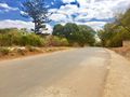
File:Mushakashela Road - Woodlands.jpg |description={{en|1=Mushakashela Road in Woodlands, Lusaka}} [[Category:Roads in Lusaka]](1,280 × 960 (202 KB)) - 05:10, 11 August 2016- | caption = Mushakashela Road in [[Woodlands]] '''Mushakashela Road''' is a street located in [[Lusaka]]'s suburban residential area of [[Woodlands]]. It branches from [3 KB (218 words) - 05:12, 11 August 2016
File:Omelo Mumba Road - Lusaka.jpg |description={{en|1=Omelo Mumba Road in [[Lusaka]]'s [[Rhodes Park]] area}} [[Category:Roads in Zambia]](1,258 × 658 (73 KB)) - 13:08, 22 April 2017- .... It stretches from [[Great North Road]] in [[Mandevu]] to [[Libala Road]] in [[Kalundu]]. [[Category:Transport in Zambia]]236 bytes (31 words) - 08:47, 13 January 2023
- [[Image:ZM-Samfya.png|thumb|Location of Samfya in Zambia]] '''Samfya''' is a town located in the [[Zambia]]n province of [[Luapula Province|Luapula]]. It is the center of [[Samfya D2 KB (253 words) - 19:48, 29 December 2017
- [[Image:ZM-Lukulu.png|right|225px|Location of Lukulu in Zambia]] ...er provide most of the local diet, and some are exported to other parts of Zambia away from the river.2 KB (343 words) - 04:04, 14 January 2023
- |settlement_type=[[Districts of Zambia|District]] |image_map =Zambia Luangwa District.png3 KB (340 words) - 15:11, 14 July 2016
- ...capital, [[Lusaka]], to the principal tourist destination, [[Livingstone, Zambia|Livingstone]], Southern Africa. ..., the Livingstone road has never been widely called the "Great South Road" in the style of its north, east and west counterparts.1,017 bytes (148 words) - 19:04, 1 September 2016
- ...e main highway of the [[Southern Province, Zambia|Southern Province]] of [[Zambia]] from the capital, [[Lusaka]], to the principal tourist destination, Livin ..., the Livingstone road has never been widely called the "Great South Road" in the style of its north, east and west counterparts.1 KB (152 words) - 12:14, 1 July 2016
- ...lacking roads and being off the usual tourist tracks, but this may change in the future. Like most national parks it is unfenced allowing free movement618 bytes (91 words) - 19:37, 23 August 2021
- [[Image:ZM-Kawambwa.png|right|225px|Location of Kawambwa in Zambia]] '''Kawambwa''' is a town in the [[Zambia]]n province of [[Luapula Province|Luapula]] located on the edge of the nort1 KB (211 words) - 14:29, 28 February 2017
- ...lacking roads and being off the usual tourist tracks, but this may change in the future. Like most national parks it is unfenced allowing free movement637 bytes (94 words) - 12:26, 2 November 2016
- ...lacking roads and being off the usual tourist tracks, but this may change in the future. Like most national parks it is unfenced allowing free movement637 bytes (94 words) - 18:27, 8 September 2017
- ...lacking roads and being off the usual tourist tracks, but this may change in the future. Like most national parks it is unfenced allowing free movement632 bytes (94 words) - 12:42, 1 May 2017
- ...lacking roads and being off the usual tourist tracks, but this may change in the future. Like most national parks it is unfenced allowing free movement632 bytes (94 words) - 12:28, 19 April 2018
- | image = Cairo Road - Lusaka - Zambia - 2017.jpg | caption = Cairo Road in Lusaka in 20173 KB (319 words) - 09:10, 24 July 2017
- ...before that, the Great North Road ran through Bulawayo and [[Livingstone, Zambia]] to Lusaka. The portion from Mbala to Mupulungu could be regarded as a sp ...ika-Tanzania highway (the [[Tanzam Highway]]) via [[Tunduma]] was upgraded in the 1960s and provided a good route through to Dar es Salaam and Arusha, th2 KB (281 words) - 06:31, 1 July 2016
- |settlement_type=[[Districts of Zambia|District]] |image_map =Zambia Kawambwa District.png3 KB (328 words) - 02:50, 30 August 2016
- |settlement_type=[[Districts of Zambia|District]] |image_map =Zambia Lukulu District.png3 KB (334 words) - 20:30, 1 September 2016
- |settlement_type=[[Districts of Zambia|District]] |image_map =Zambia Mumbwa District.png3 KB (346 words) - 15:46, 14 July 2016

