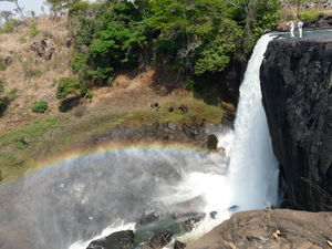
Chishimba Falls
The Luombe River 7.2 km from Chilubula Mission in Kasama District makes a beautiful water fall called: Chishimba Falls (older: Chisimba Falls). The Luombe river joins the Lukulu River shortly after the falls.
Location directions: Drive from Kasama center on the M3 westbound for about 24km, then take the junction to the D20 road. After 11km on the D20 follow the sign "Chishimba Falls 700m - National Monument" to the left. A hydro-electric power plant (owned by ZESCO) is located above the falls.
GPS:
- M3/D20 junction: -10.165617,31.001737
- Turn left from D20: -10.103037,30.928463
- Chishimba Falls parking lot: -10,10827500,30,91742900
Over a distance of 300m there are three successive falls:
- Upper fall: Mutumuna Falls has a drop of 20m
- Middle fall: Kayela Rapids
- Lower fall: Main Fall, also called the Chishimba Fall with a drop of 30m
Here you can enjoy the scenic beauty of the riparian forest.
The Chishimba Fall belongs to the Monuments and Historic Sites of Zambia.
References and Web Links
- Leaflet "chishimba falls", National Heritage Conservation Commission , 2009
- Zambia's waterfall Wonderland: Zambia Tourism
- The Geographical Journal, Vol 86, No 4 (Oct 1935), pp. 356–357: Template:JSTOR
- Bradt Travel Guide, p. 339, at Google Books
Coordinates: 10°06′43.9″S 30°54′54.3″E / 10.112194°S 30.915083°E
