File:STS51G-034-0012 Lake Tanganyika June1985.jpg
From Chalo Chatu, Zambia online encyclopedia

Size of this preview: 600 × 600 pixels. Other resolutions: 240 × 240 pixels | 480 × 480 pixels | 768 × 768 pixels | 1,024 × 1,024 pixels | 2,048 × 2,048 pixels | 5,266 × 5,266 pixels.
Original file (5,266 × 5,266 pixels, file size: 10.81 MB, MIME type: image/jpeg)
Summary
| Description |
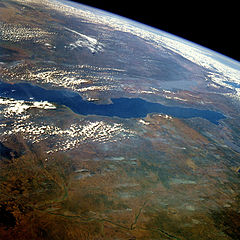
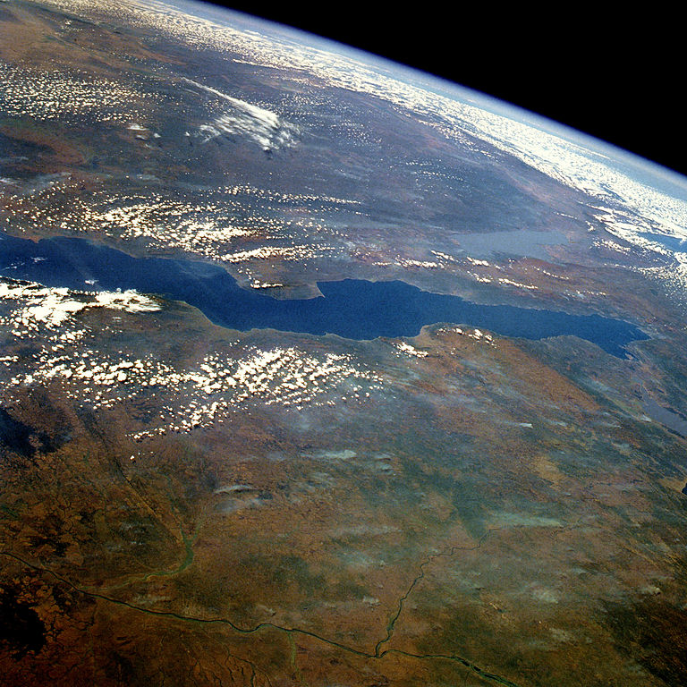
English: STS51G-034-0012 Lake Tanganyika, Tanzania, Zaire, and Zambia June 1985
This east-looking, high-oblique photograph features Lake Tanganyika—the second deepest freshwater lake in the world with a maximum depth of 4710 feet (1436 meters) and the longest lake in the world, stretching 410 miles (660 kilometers) north to south. Its width varies between 10 and 45 miles (16 and 72 kilometers). The lake, bordered on either side by steep slopes, fills a long narrow trough in the western arm of Africa’s Great Rift Valley and supports a thriving fishing industry. The lake basin, a landform in which a block of the Earth’s crust dropped down between blocks that rise on either side, began to form nearly 25 million years ago as part of the Great Rift Valley. On the lake’s west shore is Tanganyika’s sole outlet, the Lukuga River, which is a tributary of the Zaire River (northwest portion of photograph). The Zaire River flows westward and empties into the Atlantic Ocean. Other features in the photograph are shallow, silt-laden Lake Rukwa to the east of the lake and the extreme northern tip of Lake Nyasa near the southeast horizon. |
| Date | |
| Source | http://eol.jsc.nasa.gov/sseop/EFS/photoinfo.pl?PHOTO=STS51G-34-12 |
| Author | NASA |
Licensing
| This file is in the public domain in the United States because it was solely created by NASA. NASA copyright policy states that "NASA material is not protected by copyright unless noted". (See Template:PD-USGov, NASA copyright policy page or JPL Image Use Policy.) | ||
 |
Warnings:
|
Original upload log
Transferred from en.wikipedia to Commons using For the Common Good.
The original description page was here. All following user names refer to en.wikipedia.
| Date/Time | Dimensions | User | Comment |
|---|---|---|---|
| 13:48, 30 May 2012 | 5,266 × 5,266 (11,333,456 bytes) | w:en:Lukemcurley (talk | contribs) | (Improved brightness and contrast of the photo.) |
| 13:47, 30 May 2012 | 5,266 × 5,266 (8,806,419 bytes) | w:en:Lukemcurley (talk | contribs) | (Uploading a public-domain item using [[Wikipedia:File_Upload_Wizard|File Upload Wizard]]) |

|
The categories of this image need checking. You can do so here.
|
File history
Click on a date/time to view the file as it appeared at that time.
| Date/Time | Thumbnail | Dimensions | User | Comment | |
|---|---|---|---|---|---|
| current | 22:01, 23 June 2013 | | 5,266 × 5,266 (10.81 MB) | wikimediacommons>OgreBot | (BOT): Reverting to most recent version before archival |
File usage
The following page uses this file: